| Forum Home | | Log in | | Signup | | My Page |
Rules | | FAQ | | Boards | | Members | | Search |

|
|
||||||||||||||||||||||||||
| The above list shows replies to the following message: |
|
Msg. 00144 of 00575 |
|
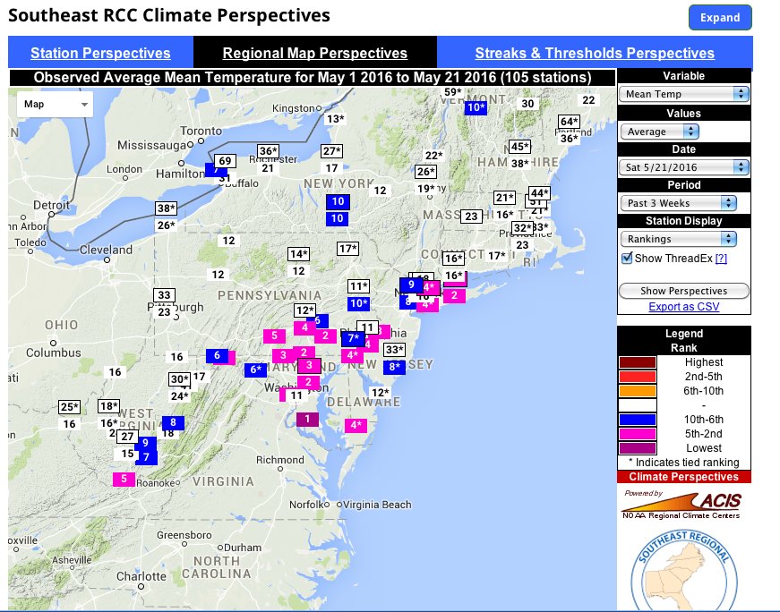
May 23, 2016 D.C.âs worst May ever, explained
By Jason Samenow So far this May, D.C. has had a record number of rainy days (19 of 23) and the coolest high temperatures since 1882. This Mayâs afternoon highs are running an incredible 15 degrees cooler than last Mayâs. And we still havenât hit 80 degrees. The Southeast Regional Climate Center says D.C.âs recent temperatures most resemble San Franciscoâs. Why has D.C.âs weather been so awful this month? Thereâs a very simple explanation. The storm track has been stuck over the Mid-Atlantic, continuously cycling weather system after weather system through the region â like a conveyor belt.
The jet stream, the high altitude river of air along which storms usually track, has pointed at and run through the Mid-Atlantic throughout the month.
It is perfectly normal for the D.C. area to be caught in the jet streamâs meandering flow during May. In fact, May is D.C.âs wettest month on average, because the jet routinely zips through the region. But usually, this so-called atmospheric super highway is not fixed on the region for weeks on-end, but on the move. The jet stream is powered by temperature contrasts, flowing fastest where warm and cool air collide. So when much of southern and central United States start to turn summery as May wears on, its average position shifts toward the northern U.S. Once that shift occurs, D.C. tends to have more warm, sunny days, and fewer cool, damp days.
This May, however, the usual northern jog of the jet stream hasnât yet occurred in the Mid-Atlantic, although itâs right around the corner. While itâs tempting to try to find an explanation for this, there isnât one. The specific configuration and position of the jet stream in any given year at a given location is somewhat random. Last year, it moved north of the Mid-Atlantic at the very beginning of May and highs were in the 80s for almost the entire month. Very little rain fell. Sometimes certain atmospheric patterns like El Nino can stack the deck for certain jet stream configurations, but thereâs no clear association between El Nino and cool, wet Mays in D.C. This Mayâs relentless rainy, cool pattern is best attributed to bad luck, in my view. If youâre curious just how rainy, cloudy and cool this month has been, Iâve compiled some very telling statistics below ⦠The rain
D.C. has recorded at least a trace of rain on 19 of 23 days in May and, if we include late April, 23 of the last 27 days. 5.04 inches of rain has fallen since the beginning of May, and 5.68 inches since April 27. The clouds D.C. has had overcast conditions at noon 77 percent of the time this May, the highest fraction on record and way above the normal of 32 percent.
The cold
This Mayâs average high temperature is just 66 degrees, the second coldest on record month-to-date. It is an amazing 15 degrees cooler than last yearâs average month-to-date high of 81 degrees. Month-to-date, the only cooler year on record is 1882 (average high of 65.5 degrees).
Gold is $1,581/oz today. When it hits $2,000, it will be up 26.5%. Let's see how long that takes. - De 3/11/2013 - ANSWER: 7 Years, 5 Months |
|
|
|
|
|
|
© Webpage Design Copyright 2003-2011 http://www.atomicbobs.com/
|